
Last modified: 2021-08-26 by  klaus-michael schneider
Keywords: cotopaxi | pujili |
Links: FOTW homepage |
search |
disclaimer and copyright |
write us |
mirrors
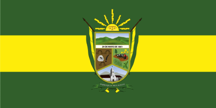 image by Ivan Sache, 28 December 2020
See also:
The parish of Mulalillo (6,379 inhabitants in 2014; 4,128 ha) is located 10
km west of Salcedo.
Mulalillo is the diminutive form of Mulaló, in
Araucanian, "snails' plain". The village was settled in 1645 by Cacique Gaspar
Zanapatín with people from Mulaló; originally called Cunchibamba, the new
village was soon known as Mulalillo.
The parish of Mulalillo was established
by the Law on Territorial Division of Ecuador promulgated on 29 May 1861.
Originally incorporated in Latacunga canton, Mulalillo was transferred to newly
formed Salcedo canton on 17 September 1919.
https://mulalillo.gob.ec/
Parish
website
Ivan Sache, 28 December 2020
The flag of Mulalillo is horizontally divided green-yellow-green with the
parish coat of arms in the center.
https://mulalillo.gob.ec/cotopaxi/simbolos-parroquiales/
Photos
https://mulalillo.gob.ec/cotopaxi/sesion-conmemorativa-por-cumplir-los-155-anos-de-parroquializacion/
https://www.facebook.com/Mulalillo-Ecuador-Salcedo-114057783661902/photos/136228184778195
Ivan Sache, 28 December 2020