
Last modified: 2022-03-05 by ian macdonald
Keywords: parana | são mateus do sul |
Links: FOTW homepage |
search |
disclaimer and copyright |
write us |
mirrors
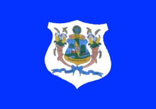 image by Ivan Sache, 10 February 2022
The municipality of São Mateus do Sul (45,806 inhabitants in 2018; 134,263
ha) is located 120 km south of Curitiba.
São Mateus do Sul was
"conquered" in 1769 by Lieutenant Bruno da Costa Figueiras, leader of the Fourth
Expedition, as a base for the occupation of Guarapuava ordered by Luiz de Souza
Botelho e Mourão, Captain of São Paulo. The place was first settled in 1877 by
Brazilian colonists; later on, Spaniards failed to establish a colony. Attracted
by rumors of petrol deposits in 1885, Germans led by Rudolph Wolff and Gustavo
Frederico Thenius established in 1885 a colony named Porto Santa Maria, as a
tribute to the patron saint's of the founders' wives and daughters. The place
was subsequently renamed to Maria Augusta as a tribute to the wife of Engineer
José Carvalho Sobrino, one of the administrators of the colony.
The
municipality of São Mateus was established by Law No. 763 promulgated on 2 April
1908 and inaugurated on 21 September 1908. The municipality was renamed to São
Mateus do Sul by a State Decree-Law promulgated in 1943.
The end of
navigation on river Iguaçu caused the decline of the town, which re-emerged in
the late 1960s when Petrobrás established a plant to process schistose extracted
locally.
https://www.saomateusdosul.pr.gov.br/
Municipal website
The flag
of São Mateus do Sul is blue with a white shield inscribing the municipal coat
of arms.
Photos
https://www.facebook.com/prefeiturasms/photos/3046929458929068
https://www.facebook.com/prefeiturasms/photos/2975923459363002
Ivan Sache, 10 February 2022