
Last modified: 2026-01-03 by rob raeside
Keywords: tacuarembó |
Links: FOTW homepage |
search |
disclaimer and copyright |
write us |
mirrors
Tacuarembó is one of 2 departments that does not have a real flag, the other being Montevideo. Through Decree 016 of 8 May 1987, a jury for a flag was designated but ended up being declared abandoned the following year. Under the same Decree in 2000, a proposal was held which was not adopted due to political dispute; as of today, there is no departmental flag.
Daniel Rentería, 11 November 2025
![[arms]](../images/u/uy-ta!.gif) image
by Daniel Mello Luchtenberg11 November 2025
image
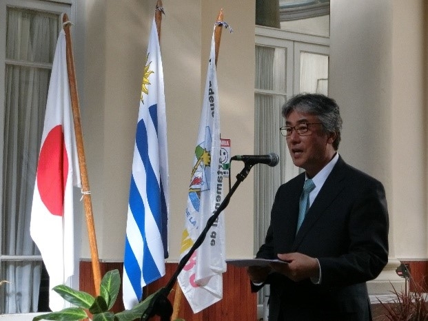
by Daniel Mello Luchtenberg11 November 2025 Mostly used in previous years, this unofficial flag depicts a white field reading Intendencia Departamental de (in black, above); and TACUAREMBÓ in purple, blue, green, yellow, and pink colors (below). In the very center, the coat of arms of the department is found, with curved blue text reading EL PAGO MAS GRANDE DE LA PATRIA underneath (The Biggest Countryland of the Fatherland).
Photo of flag in use from https://www.uy.emb-japan.go.jp
Daniel Rentería, 11 November 2025
![[arms]](../images/u/uy-ta!4.gif) image
by Daniel Rentería, 11 November 2025
image
by Daniel Rentería, 11 November 2025
based on photo from
https://www.instagram.com
This variant used in the Congress of Intendents is white with the coat of arms centered upon it, it appears.
Daniel Rentería, 11 November 2025
![[arms]](../images/u/uy-ta!3.gif) image
by Daniel Rentería, 11 November 2025
image
by Daniel Rentería, 11 November 2025
In a sense, the proposal succeeded in the fact it was chosen by a popular
vote. The flag was first hoisted on 19 June 2000 at the intersection of the
Pablo Rios road and railway. It was created through a contest, of which the
creator Andrés Bascou earned 2000 USD as the winning prize; previously being
chosen on 6 May. The flag itself was not adopted due to political dispute
between the Intendent and his successor. The flag is divided blue-white-green
horizontally, with the blue and green stripes taking roughly 1/4 of the white
stripe's height. At the top and bottom of the stripe, there are 8 pieces of a
sugarcane on each one. In the center, a golden sun is depicted. The sugarcane
recognizes the departmental name, meaning river of sugarcane fields. Green is
representative of the land; the Sun of May is found in the center for
patriotism; and blue of the sky and water.
Daniel Rentería, 11 November 2025
![[arms]](../images/u/uy-ta!2.gif) image
by Daniel Rentería, 11 November 2025
image
by Daniel Rentería, 11 November 2025
This is an incorrect flag. It depicts a
red field with a white diagonal band going from the top-left to the
bottom-right. In the center is the departmental coat of arms. It really is only
found on MercadoLibre, not used by the government at all. In my opinion, it
definitely seems like the image intentionally takes the colors of the local
Football Club (red and white).
Source:
https://commons.wikimedia.org/wiki
Daniel Rentería, 11 November 2025
![[arms]](../images/u/uy-ta).gif) image
by Daniel Rentería, 11 November 2025
image
by Daniel Rentería, 11 November 2025
from
https://commons.wikimedia.org
The coat of arms was designed by Carlos Vilson López and approved by the
Departmental Junta on 29 December 1960 through Act N°78. The motto, El pago más
grande de la Patria [The biggest countryland of the Fatherland] was apparently
adopted in 1991 to be used with it. The shield has a blue field for the sky,
having in the background the Cerro Batoví hill as the most prominent landform in
the department. At the top part, a white rectangle reads TACUAREMBO in black;
above the ribbon is the Sun of May honoring the nation and independence in
orange, yellow, and white details.
The shield, not including its top
part, is divided into three triangles by a V shape for victory created by
sugarcane remembering its name, which means river of sugarcane fields. The left
triangle depicts a field with a hand holding dirt from which wheat emerges,
showing the product of hard work and principal employment source in the land.
The right triangle depicts the Rincón del Bonete hydroelectric dam, a major
source of electric energy in the region recognizing its border with the Negro
River. The central triangle depicts (left) a sheep and (right) a cow for
ranching, another principal source of employment; the bottom part of the
triangle depicts a torch for effort and progress held by the residents. Just
above the torch, the boundaries of Tacuarembó are seen.
Source:
https://ia601500.us.archive.org/35/items/tacuarembo
Daniel Rentería, 11 November 2025