
Last modified: 2025-06-07 by rob raeside
Keywords: national ornament | tazovskiy | reindeer | tasuʼ Âvaˮ | gubkinskiy | wave | tazovskiĭ | nadym |
Links: FOTW homepage |
search |
disclaimer and copyright |
write us |
mirrors
Note the often use of serration lines in the familiar shape following the
Yamalo-Nenetsian flag, itself a stylization of the
antler crown found also in the flags of Yugra
and Tyumen Region (the latter encompassing all this)
and some other local flags.
António Martins, 27 Jan 2002
.gif) image by Alten Keeton,
26 April 2025
image by Alten Keeton,
26 April 2025
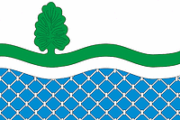
Gorkovskoye is an abolished municipality/rural settlement in Yamalo-Nenets, it
had a population of 1,428 as of the 2021 census.
COAT OF ARMS:
The
coat of arms consists of a silver top with a bright green line with a stylized
cedar tree growing out of it traveling over. The bottom half has a blue
background with a pattern of a fishing net, symbolizing the Kushevatsky fish
factory.
FLAG:
The flag is an extended design of the coat of arms.
Same silver top, same green line with the cedar tree, same blue bottom with the
fishing net.
SOURCES:
https://geraldika.ru/s/25569
https://geraldika.ru/s/25570
https://ru.wikipedia.org/wiki/Горковское
Flag and coat of arms
approved by the Assembly of Deputies of the rural settlement of Gorkovskoye on
December 25th, 2009.
Alten Keeton, 26 April 2025
From adm.purpe.ru/images/flag1.gif.
Pascal Gross, 26 Jan 2002
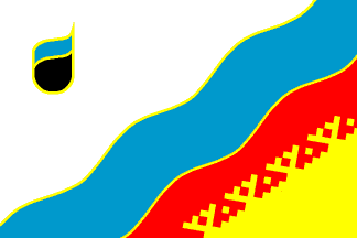
A pretty colorful and handsome flag of Russia’s newest town: Gubkinskiy,
located in Yamalo-Nenets Autonomous Okrug. Established in 1986, legalized in
1988.
Chrystian Kretowicz, 25 Jan 2002
Undoubtedly an yamalian flag, with the Tyumen’s
“antler crown” motive stylized just like in the
Yamal-Nenetsia aut. flag.
António Martins, 28 Nov 2002
The symbol at top hoist reminds me of a petrochemical industry logo,
which may be not far from the truth — this region being one of Russia’s
main oil and gas extraction centers.
António Martins, 27 Jan 2002
.gif) image by Alten Keeton,
26 April 2025
image by Alten Keeton,
26 April 2025
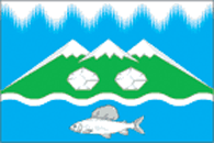
Kharp is a small village/urban-type settlement in Yamalo-Nenets, with a
population of 6,413 as of the 2010 census.
COAT OF ARMS:
We start at
the top where there's a long row of silver needles, these needles are a tribute
to the town's name (which means northern lights). Below are three peaks with
snow above the timber line, as the mountains lie on a grassy field. below the
tri-peak system are two stones made also of silver. As we get to the coastline,
it's grassy with a silver border. In the bright blue color of the Arctic Ocean
is a large fish.
FLAG:
The flag is very similar to the coat of arms,
basically an extended version of it. However, there are small differences. The
silver needles in the sky and the silver border of the coastline have been
changed to a bright white, and of course there are more humps of each.
SOURCES:
https://geraldika.ru/s/31139
https://geraldika.ru/s/31140
https://en.wikipedia.org/wiki/Kharp
Alten Keeton, 26 April 2025
.gif) image by Alten Keeton,
25 April 2025
image by Alten Keeton,
25 April 2025
Labytnangi is a town in Yamalo-Nenets, with a population of 26,936 as of the
2010 census.
COAT OF ARMS:
The coat of arms consists of two great
peaks with one smaller peak in between, planted in a snowy field. Above the
smallest peak is a six-armed snowflake in the blue sky. On the smaller peak is a
small tree, above the centered deer head. The deer head is colored in a
golden-brown, with a white outline on the face along with a white nose and black
slanted eyes. On each side of the deer head lies a group of trees, three on each
side and mirrored. The trees have a light green base with a thick dark green
border and a thin yellow border on top of the dark green. Below the deer head
lies a bumpy, snowy coastline into the blue Arctic Ocean.
FLAG:
The
flag is similar to the coat of arms, but with visible changes. On the left is a
blue strip representing the sky, with a snowflake at the top of the strip. To
the right of the strip is a big snowy area with the deer head in the middle.
This time however it is more golden, with a yellow nose, eyes outlined in
yellow, and the head being outlined in yellow and green. Above and to the sides
are the same seven trees, but with a white core and a dark green outline.
SOURCES:
https://geraldika.ru/s/3906
https://geraldika.ru/s/14976
https://en.wikipedia.org/wiki/Labytnangi
Alten Keeton, 25 April 2025
.gif) images by Alten Keeton,
10 May 2025
images by Alten Keeton,
10 May 2025
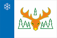
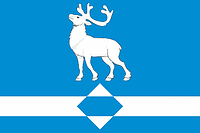
Longjugan is a small village in Yamalo-Nenets, it had a population of 1,783 in
the 2021 census.
COAT OF ARMS:
The coat of arms consists of an azure
field with a silver reindeer at the top, below is a silver belt with a rhombus
in the center striped in blue and silver.
FLAG:
The flag is the same,
just the belt and field extended to fit the aspect ratio.
ADOPTION:
Both the flag and the coat of arms were approved by the Assembly of
Deputies of the municipality of the village of Longjugan and adopted on February
28th, 2013.
EXTRA INFORMATION:
The person who came up with the idea of
the coat of arms was Konstantin Mochenov, the
artist was Anna Garcia, and the person who made the justification of the symbols
was Vyacheslav Mishin.
Alten Keeton,
10 May 2025
.gif) image by Alten Keeton,
26 April 2025
image by Alten Keeton,
26 April 2025
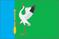
Lopkharinskoye is an abolished municipality/rural settlement in Yamalo-Nenets,
with a population of 469 as of the 2010 census.
COAT OF ARMS:
The coat
of arms consists of a mostly green background with a strip of blue at the hoist.
In the green side (and in some of the blue side) is a silver crane, with partial
black wings, an open beak in scarlet, and scarlet limbs. It stands on one leg
and holds a golden paddle in the other.
FLAG:
The flag is exactly the
same as the coat of arms, just extended. It as the same green and blue
background, with a silver crane and a golden paddle.
SOURCES:
https://geraldika.ru/s/25007
https://geraldika.ru/s/25008
https://ru.wikipedia.org/wiki/Лопхаринское
Flag and coat of arms approved by the Assembly of Deputies of the municipality
of Lopharinskoye on October 22nd, 2009.
Alten Keeton,
26 April 2025
.gif) image by Alten Keeton,
26 April 2025
image by Alten Keeton,
26 April 2025
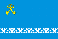
Muravlenko is a town within Yamalo Nenets, it's population was 33,391 in the
2010 census.
COAT OF ARMS:
The coat of arms consists of a blue
background with two gold keys that are crossed and interlaced. At the bottom of
the blue barrier is an assortment of white russes. Below the russes is a black
background that goes to the end of the coat of arms.
FLAG:
The flag is
different, but of course takes from the coat of arms. The flag has a blue
background with the same crossed and interlaced gold keys. Towards the bottom is
the same assortment of white russes found on the coat of arms.
SOURCES:
https://geraldika.ru/s/533
https://geraldika.ru/s/2047
https://en.wikipedia.org/wiki/Muravlenko
Alten Keeton,
26 April 2025
 Mikhail Revnivtsev, 4 Apr 2005
On official web-site of Administration of Municipality of Nadym-city and
Nadym-rayon of Yamal Nenetskian autonomous district (Yamal is peninsula,
Nenets - is people) http://www.nadymregion.ru/engine.php?c=1044891076 (in
Russian) is flag of Municipality of Nadym-city and Nadym-rayon
Mikhail Revnivtsev, 4 Apr 2005
.gif) image by Alten Keeton,
10 May 2025
image by Alten Keeton,
10 May 2025
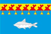
Nyda is a small village located in Yamalo-Nenets next to the Nyda river mouth,
it had a population of 1,870 in the 2021 census.
COAT OF ARMS:
In the
azure field on the bottom half is a silver muksun below the yellow belt that is
tiled and covered with four intricate red tile structures on the belt. Hanging
off of the belt is eight yellow pennants.
FLAG:
The flag is very
similar to the coat of arms, but there are some noticeable differences. The
eight pennants are more spread out hanging from the belt, and the number of red
structures has increased from three to seven.
Sources:
https://geraldika.ru/s/30023
https://geraldika.ru/s/30024
https://ru.wikipedia.org/wiki/Ныда_(село)
Alten Keeton, 10 May 2025
The flag and arms were officially adopted on 2010-10-26. They were also
registered in the State Heraldic Register of the Russian Federation.
Tomislav Todorovic, 10 May 2025
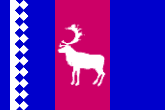 image by António Martins, 28 Nov 2002
Tazovskiy county lies high in the northern hemisphere, behind the Polar circle. Coordinates of the regional centre (urban type settlement Tazovskiy) are 67,5°N 78,6°E. The territory is made of peninsulas: Tazovskiy (a.k.a. Small Yamal), Gydan, Mamont, Yavaj; and islands: OleniY, Shokalskogo, Neupokoyeva, Velnitskogo and Damned islands. The area has 174 000 km2 with 16 300 inhabitants in five settlements, including 6200 in Tazovskiy city.
Taz-river basin natives call it the Tasu-Yam-yaha — the yellow large river. The Russian state arrived at Tazovskiy peninsula in the 16th century and set a sable fur trade post, soon ruined. Second settlement in 1883: factory Khalmer-S*d* (nenets for "tombs on hills") is founded. Soviet Russia, in December 10, 1930, creates Yamalo-Nenets national (later autonomous) district and within it Tazovskiy rajon with the centre in village Khalmer-S*d* — renamed Tazovskiy in 1949.
Mikhail Revnivtsev, 11 Jun 2002, based on fakttv.ru/region/power/
yantz.gif) image by Mikhail Revnivtsev, 11 Jun 2002
image by Mikhail Revnivtsev, 11 Jun 2002